Wednesday, March 11, 2009

March 11, 2009

Happy Birthday, Rosemary!


Here's Robinson Crusoe Island and Easter Island.


On March 2 the seas were too rough for us to tender to Robinson Crusoe Island (formerly known as Mas a Tierra). This is the largest island of the Chilean Juan Fernandez archipelago. However, not to worry, the natives came to our ship and we really had a great time listening to their music and dancing with the “pirates”. We heard an excellent lecture the day before with the more factual version of Alexander Selkirk’s four years on this island before being rescued by Captain Woods Rogers. It seems Daniel Defoe embellished a bit on the story. Here are some pictures of our party - I was the very happy recipient of a pirate’s hat from the singer in the band - Laura would have been proud of me!


Robinson Crusoe Island


The Local Band


The Leader of the Band and my new hat.


My Dance Partner


My friend, Ruth, and her new friends.


Some Island Facts


Easter Island - March 6

We were crossing our fingers that we would have better luck weather-wise at Easter Island than we had at Robinson Crusoe Island. We were so happy to have a beautiful sunny day and seas that were not too rough for the tenders.

The most isolated island in the world, Easter Island was named by Dutch explorer Jacob Roggeveen when he landed here on Easter Sunday in 1722. The explorer found a thriving native population that lived in tight-knit communities of hare paengas, or boat-shaped houses. To communicate they had created rongorongo, a beautiful script and the only written language in all of Polynesia. But their greatest achievement was the hundreds of sad-eyed stone statues called moais they erected to honor their ancestors. By the time British Captain James Cook anchored here, just 50 years later, he found only several hundred people and many of the moais toppled from their foundations. During the ensuing century, raids by slave traders, disease, and colonial disenfranchisement further decimated the local population. So many people died that to this day, no one has been able to decipher the language. Today Easter Island’s primary industry is tourism, and the residents, most of whom are descended from the original inhabitants, are extremely proud of their island’s past.

Couple of other bits of information - the people of Easter Island called themselves the Rapa Nui and the word “Ahu” describes the platform upon which the moais are erected.


Easter Island


Quarry from which Moai were carved (volcanic rock)


One of hundreds of Moai in this quarry that weren't completed and moved to an Ahu.


A carving still in the rock (face laying down)


Carved Moai still in stone (El Gigante - 72 feet)


Ahu Tongariki - 15 Moais stand side by side on a 200 foot-long ahu.
This was restored after having been destroyed by a tidal wave in 1960.


Ahu Tongariki without tourists!


Me & Moais - One behind me is 92 tons. - hope I don't catch up!


Lunch at Anakena Beach


Anakena Beach


Ahu Ko Te Reku

The eyes have been put in this Moai which is the point at which it was believed that the spirit of the ancestor being represented by the Moai enters the Moai. The Moai face inland so that the spirit of the ancestor protects the inhabitants of the island. Our ship is to the left of the Moai.

Later............

Monday, March 9, 2009

March 8, 2009

I'm going to catch up today. This post will cover Puerto Montt and Valparaiso, Chile.


We had a lovely tour on February 26 visiting the Petrohue Falls, Puerto Varas & getting spectacular views of the Osomo Volcano. This area, just north of Puerto Montt is called the Lake District. There is a strong German influence in this area, so while visiting Puerto Varas, we were compelled to have a coffee and German pastry. The day we visited was beautiful - sunny and warm. Our tour guide told us we were very lucky since this area experiences around 252 days of rain per year. I have a million pictures of the volcano, but will not post them all!!


Petrohue Falls (North of Puerto Montt)


Osomo Volcano


Petrohue Falls


On February 28 we visited Valparaiso. This was once a very busy port and has a strong European influence. Valparaiso was a trading base in the Southern Pacific for the U.S and Europe, an international banking center as well as a key port for US shipping between the East Coast and California and European ships that rounded Cape Horn. It’s decline was the result of the development of steam ships which stopped at the coal mines around Concepcion instead, the opening of the trans-continental railway in the US, and then the opening of the Panama Canal in 1914. It declined further due to the development of a container port in San Antonio, the shift of banking to Santiago and the move of the middle class to nearby Vina del Mar, but Valparaiso is now reviving. Some of the beautiful buildings have been taken over by the Navy and the University. You will see a picture below of a beautiful home which is being renovated and will become an art museum. Of the 30 funiculars, 16 are still operational and we had an opportunity to ride on one. As you can see, Valparaiso is built on a hill.


Valparaiso


Awesome Pipe Organ in Anglican Church


Popular Boutique Hotel in Renovated District


Memorial to Chilean Heroes


Funicular


Once a home, soon to be an art museum.

Next post Easter Island and Robinson Crusoe Island......

Wednesday, February 25, 2009

February 25

On February 20, we docked at Ushuaia (pronounced oooSCHWAYyah), Argentina. Ushuaia claims to be the southernmost “city” in the world. Puerto Williams, Chile, is further south, but is technically a “town”, not a city.

I took a tour of the Tierra del Fuego National Park and was surprised to learn that the terminus of Route 3 (the Pan American Highway) is in this park. Highway 3 begins in Fairbanks, Alaska (wish I had taken a picture of the origin - little did I know one day I would be at the end). The distance from Fairbanks to Ushuaia is 17,848 kilometers. (Laura - there are people that bike it!)

Also, the southernmost golf course is in Ushuaia. Might have been fun to play at the southernmost golf course having played at the northernmost in Fairbanks. It was a little nippy here that day and I do have pictures.


Ushuaia Golf Course


Ensenada Bay in Park


Freshwater lake in Park


End of Highway 3


End of the Road!


Our Location


View from Restaurant/Gift Shop


Leaving Ushuaia


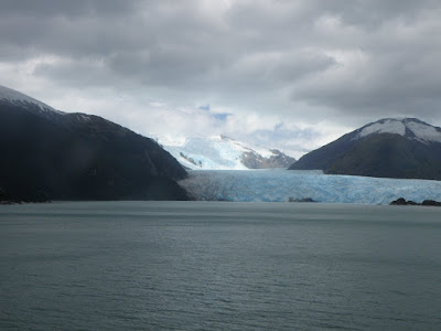
From the afternoon of the February 20 through today, we have been cruising the Chilean fjords with a stop in Punta Arenas on Sunday February 21. Tomorrow we arrive in Laguna San Rafael where we will board catamarans and get a real close up of a glacier.

A little tidbit about icebergs. Technically, an iceberg has 10 feet of ice showing above the water. Icebergs have 90% of their ice below water, so minimum size of an iceberg is 100 feet = 10 above, 90 below. One of my pictures shows a piece of ice which would qualify as an iceberg. Unfortunately the rescue boat pulled away before I got the picture, so you can’t see the contrast of the rescue boat next to the iceberg (the boat plus the 6 foot tall men on board).

Here’s a sampling of the glaciers so far:


Holland Glacier


Italia Glacier


Alemania Glacier


Amalia Glacier


Scenery in Amalia Glacier Area


Iceberg Glacier (Located in Iceberg Fjord)


Rescue Boat Pulling away from Iceberg


Me & San Rafael Glacier (February 25 from catamaran)


San Rafael Glacier

Tomorow Puerto Montt.....

Tuesday, February 24, 2009

February 24

Today's post will cover Puerto Madryn, Port Stanley on East Falkland Island and Cruising Cape Horn.


Puerto Madryn, Argentina - February 16

Puerto Madryn is a very windy, arid city. Puerto Madryn has an aluminum factory, sheep and is 40 km from Peninsula Valdes, a wildlife reserve. From March to December, many tourists come to see the southern right whales who feed, mate, give birth & nurse their offspring here. In non-whale season, you can still see the elephant seals (which are molting right now) and the sea lions. I had a Signature tour here, and Fernanda drove what seemed like forever to see the elephant seals and sea lions. It was nice to get away from the bigger cities and I had a great walk along the beach to see the elephant seals.


Gaucho Herding Sheep


Find the Hare


Lighthouse at Punta Delgada


Punta Delgada (elephant seals in background)


Sea Otter


Elephant Seals (molting - there's fur all over the beach!)


Sea Lions (the babies are the little black guys


New Gulf - Puerto Madryn


Port Stanley, East Falkland Island - February 18

We were so lucky to be able to anchor off Port Stanley since the day before we arrived they had 90 mile an hour winds. If we had that weather, we would not have been able to stop. Here I went on a Regent Tour to Sparrow Cove to see the Gentoo penguins. We took a boat from the ship to the shore where we were transported to 4-wheel drive vehicles to travel 3 miles (took 25 minutes) to get to the penguins. Very bumpy - had to hang on for dear life.

After visiting the penguins, we took the tender into Port Stanley and looked around the town. Very fun day.


Yes, we're in the Falkland Islands.


Christ Church Cathedral


Penguins at Sparrow Cove


Couldn't catch what he was saying.


Me & Penguin


Penguin Poop


Cruising Cape Horn - February 19

We were also very fortunate to have very calm seas while we cruised around Cape Horn. There is an Albatross Monument on Cape Horn (picture below). Here is what is engraved on the monument:

I, the albatross that awaits you at the end of the world…..

I, the forgotten soul of the lost sailors that crossed Cape Horn from all the seas of the world.

But die they did not in the fierce waves,
For today towards eternity in my wings they soar
In the last embrace of the Antarctic winds.

Sara Vial - Dec. - 1992


First Look at Cape Horn


Patiently waiting for dolphin to reappear - no luck.


Evidence I was there.


More Cape Horn - Lighthouse, home & chapel on hill in front.


Another view of Cape Horn.


Another view of lighthouse, home & chapel.


Albatross Monument


Another view...


To be continued....................